News Herald from Port Clinton, Ohio • 2
- Publication:
- News Heraldi
- Location:
- Port Clinton, Ohio
- Issue Date:
- Page:
- 2
Extracted Article Text (OCR)
it it PAGE 2 Port Clinton THE DAILY NEWS Oak Harbor Friday, April 12, 1968 President Expresses Outrage At King Slaying, Violence In Cities WASHINGTON (AP) President Johnson, voicing outrage at the slaying of Dr. Martin Luther King and the violence that followed it, has signed an historic housing bill as a federal task force girded to enforce the new law. It is the third landmark civil rights bill to become law since Johnson entered the White House. America is outraged at the assassination" of King, the President told a crowd of civil rights leaders, Congress members and government leaders in the East Room of the White House Thursday. "And America is also outraged at the looting and burning that defiles our democracy.
"We just must put our shoulders together and put a stop to both," he said of the violence that takes the lives of men like King and of the slum riots. The signing came one week after King's death in Memphis, Tenn. The President recalled that King was among the civil rights leaders who met with him two years ago to lay the groundwork for an open-housing bill. Mrs. King was invited to attend the ceremony but could not arrange to be in Washington, White House aides said.
The new law will prohibit LEGAL NOTICE LEGAL NOTICE (q) In a recorded roadway, within Port Ann Allotment Plat 2, approximately 819 feet of 6- inch water main, beginning at North Shore Boulevard and extending southerly to the point of termination. (r) In a. recorded roadway, within Erie View Subdivision, approximately 845 feet of 6-inch Shore Boulevard and extending water main, a beginning at North southerly to the point of termination. (s) In Margaret Drive, a recorded roadway, approximately 813 feet of 6-inch water main, beginning at North Shore Boulevard and extending northerly to a terminus at Joann Lane. (t) In Arman Road, recorded roadway, approximately 1,036 feet of 6-inch water main, ginning at North Shore Boulevard and extending northerly to a.
terminus at Joann Lane. (u) In Joann Lane, a recorded roadway, approximately 464 feet of 6-inch water main, beginning at Margaret Drive and extending to a terminus at the westerly boundary of Arman's Subdivision C. (v) In a private roadway along the westerly property line of lands, formerly or now owned by Mary Barnholt and the recorded roadway in Barnholt Allotment Plats 1 and 2, beginning at North Shore Boulevard and extending northerly with approximately 1,451 feet of 6-inch water main, thence westerly in a recorded roadway of Barnholt Allotment ent Plat with approximately 693 feet of 6-inch water main to the point of termination. (w) In a recorded roadway within Barnholt Allotment Plats 2 and 3, approximately 694 feet of 6-inch water main, beginning at the recorded roadway in Barnholt Allotment Plats 1 and 2 and and extending westerly to a terminus at the westerly boundary of said Plats 2 and 3. SECTION (a) In Riedmaier Drive, a recorded roadway, apporximately 2,074 feet of 6-inch water main, beginning at State Route No.
163 and extending northerly and easterly to a terminus at the easterly boundary line Holiday Harbor Subdivision 1st Addition. (b) In Melody Lane, a recorded roadway, approximately 305 feet of 6-inch water main, beginning at Riedmaier Drive and extending easterly to a terminus at the easterly boundary line of Holiday Harbor Subdivision 1st Addition. (c) In Channel Grove, a recorded roadway, approximately 1,257 feet of 8-inch and 92 feet of 2-inch water main, beginning at State Route No. 163 and extending northerly to the point of termination. (d) In Roanoke Road, a recorded roadway, approximately 470 feet 6-inch water main, beginning at Channel Grove and extending easterly to a terminus at Sackett Road.
(e) In Sackett Road, a recorded roadway, approximately of 6-inch and 141 feet 695, 2-inch water main, beginning at Roanoke Road and extending easterly to a point of terminations tion. (f) In East Harbor Road, a recorded roadway, approximately 698 feet of 6-inch water main, beginning at Roanoke Road and extending northerly to a terminus at a recorded roadway. (g) In a recorded roadway, in Channel Grove Subdivision, approximtely 229 feet of 6-inch and 87 feet of 2-inch water main, beginning at Sackett Road and extending westerly to a point of termination. the northerly recorded rollawaln in Channel Grove 1st Addition, approximately 729 feet water main, beginning at Channel Grove and extending westerly to a terminus at Steele Road. (1) In the southerly recorded roadway in Channel Grove 1st Addition, approximately 729 feet 6-inch water main, beginning at Channel Grove and extending westerly to a terminus at Steele Road.
(j) In a recorded roadway, bounded on the east by Lots 24, 25, 26 and 28 in Channel Grove 1st Addition, approximately 261 feet of 2-inch water main, beginning at the southerly recorded roadway in said addition and extending northerly to a terminus at the northerly recorded roadway in said addition. (k) In a recorded roadway, bounded on the east by Lots 34, 35, 36, and 38 in Channel Grove 1st Addition, approximately 261 feet of 2-inch water main, beginning at the southerly recorded roadway said addition and extending northerly to a terminus at the northerly recorded roadway in said addition. In Steele Road, a recorded roadway, approximately 1,083 feet of 6-inch water main, beginning at State Route 163 and extending northerly to a point of termination. (m) East Harbor Road, a recorded roadway, appriximately 1,071 feet of 6-inch water main, beginning at State Route No. 163 and extending northerly to a point of termination.
(n) In a private roadway, in Grant's Allotment, approximately 743 feet of 6-inch and 130 feet of 2-inch water main, beginning at State Route No. 163 tending northerly and westerly to a point of termination. (0) In East Harbor View Avenue, a recorded roadway, approximately 730 feet of 6-inch water main, beginning at State Route No. 163 and extending northerly to a termius at Bass Avenue, (p) In Harbor View Avenue, 8 recorded roadway, approximately 721 feet of 6-inch water main, beginning at State Route No. 163 and extending northerly to a terminus at Bass Avenue.
(q) In Bass Avenue, recorded roadway, approximately 200 feet of 6-inch and 91 feet of 2- inch water main, beginning at East Harbor View Avenue and extending westerly to a point of termination. (r) In a recorded roadway in North View Allotment, mately 809 feet of 6-inch water main, Beginning at State Route No. 163 and extending northerly to a point of termination. (8) In Plum Street, a recorded roadway, approximately 663 feet of 6-inch water main, be. ginning at State Route No.
163 crimination in 80 per cent of all housing sales and rentals by 1970, but much of it takes effect next Jan. 1. The law also makes it a federal crime threats or violence to interfere with anyone seeking to exercise his civil rights and prohibits the crossing of state lines with intent to incite rioting. The measure follows up the dis-1964 Civil Rights Act which Con- of Lot 44 in said allotment; thence westerly along southerly line of Lot 44 to the centerline of roadway; thence continuing westerly along the southerly line of Lot 29 in Berwyn Project Allotment No. 1 to the southwesterly corner of Lot 29; thence southerly along the westerly boundary of Berwyn Project Allotment No.
1: thence westerly along a line, which line is the extension northerly line of Lot 21 westerly, to a point on the westerly line of Parcel No. 79, formerly or now owned by the Chemstone Corporation; thence southerly along the westerly line of said Parcel No. 79 and the easterly line of a Parcel No. 80, formerly or now owned by the Chemstone Corporation, to a point, which point is 1o- cated at the intersection of the easterly extension of the southerly line of Lot 16 in Ott's Subdivision, Block 4 with the last described line: thence westerly along the easterly extension of and the southerly line of Lot 16 to the southwesterly corner of said Lot 16 in said subdivision, Block 4 in Great Lot 14, Section thence continuing westerly along the last described line extended to a point within a parcel of land, formerly or now owned by Mearl and Ruth Richards, which point is located at the intersection of the westerly line of the east one-quarter of Great Lot 14 in Section 2 with the last described line; thence southerly along the westerly line of the east one-quarter of Great Lot 14 in Section 2 to a point, which point is located at the intersection of the easterly extension of the southerly line of Lot 6 in Port Ann Allotment, Plat 2 with the last described line; thence westerly along the easterly extension of and the southerly line of Lot 6 to the southwesterly corner of Lot 6 in said allotment; thence southerly along the westerly line of Port Ann Allotment, Plat 2, and the westerly line of lands formerly or now owned by James Merrick and the easterly line of Erie View Subdivision Plat 1 and easterly line of lands, formerly or now owned by Myra Flickinger, to a point, which point is located at the intersection of the easterly extension of the southerly line of an 0.82 acre parcel of land, formerly or now owned by Michael and Olga Marysz, with the last described line; thence westerly along the easterly extension of anl the southerly line of said parcel to the southwesterly corner of said 0. 0.82 acre parcel; thence continuing westerly along the last described extended to a point on the easterly line of Great Lot 14, Section 2 and the westerly line of Great Lot 15 in Section 2, which line also passed through a 7.28 acre parcel of land, formerly or now owned by Armanag Stepanian; thence southerly along the easterly line of Great Lot 14 and westerly lime of Great Lot 15 in Section 2 to a point, which point is 760 feet, more or less, south of the intersection of Great Lot 14 and 15 with the centerline of North Shore Boulevard; thence westerly along a line perpendicular to the last described line to a point on the westerly line of a 16.26 acre parcel of land, formerly or now owned by Armanag Stepanian; thence southerly along the westerly line of said 16.26 acre parcel and the easterly line of a 24 acre parcel of land, formerly or now owned by Araxy Stepanian, to the centerline of State Route No.
163; thence southerly along the easterly of a 10 acre parcel of land, formerly or now owned by Dale and Beverly Lindhorst, to a point, which point is 400 ly with by the rectangular centerline measurement in Route a No. westerly 163; thence direction generally a line 400 feet southerly of and parallel to the centerline of State 163 to a point on the westerly line of Section 2, which line passed through part of Great Lot 15, and Great Lots 16, 17, 18, 19 and 20 in Section 2: thence northerly along the westerly line of Section 2 to the point of intersection of the corners of Sections 3 and 4 with the westerly line of Section thence easterly along a line which intersects the shores of Lake Erie at the most westerly point of lands, formerly or now owned by William R. Brown, on the Gravel Bar Peninsula; thence generally easterly along the shores of Lake Erie to the place of beginning. The above-described lots and lands are hereby determined to be specially benefited by the improvement described in this resolution and to the extend herein provided. Section 5.
That the 8th day of May, 1968, at 7:30 o'clock P.M., Eastern Daylight Time be and the same is hereby fixed as the time and Danbury High School Auditorium, Lakeside, Ohio, 88 the place for hearing of objeetions to this improvement, to t.ie tentative assessments, or to the boundaries of the assessment district. Section 6. That the Clerk of this Board be and he hereby is directed to have this resolution published once a week for two consecutive weeks in a newspaper printed and of general circulation in Ottawa County, the first such publication to be made at least twenty-four prior to the hearing date fixed in Section 5. and on or before the date of the second publication to send by mail a notice of the time and place of such hearing to every owner of property to be assessed for such improvement whose address is known and such notices shall state that the property of the addressee will be assessed for Sewer District. No.
7, Water Improvement 2. Upon roll call on the adoption of the resolution, vote WitS as follows: MR. COVER (yes) MR. JOHNSON (yes) MR. FOREMAN foregoing is a true and correct excerpt from the minutes of the meeting on March 4th, 1968, of the Board of Commissioners of Ottawa County, showing the adoption of the resolution above set forth.
M. C. GUTH Clerk April 12, 19, gress sent to Johnson eight months after the death of President John F. Kennedy, another assassination victim. That measure opened up all public accommodations to Negroes and strengthened their voting rights.
In 1966 Johnson signed the Voting Rights Bill which outlawed literacy tests as a requirement for voting. As Johnson was signing the new bill Thursday in a ceremony nationally telecast and broadcast, the Justice Depart- ment's Civil Rights was assigning a newly formed task force to assemble the government's enforcement program. The task force will operate under Stephen J. Pollak, ant attorney general for civil rights. It will search for violations and may refer some cases to the FBI for further investigation, Pollak said in an interview.
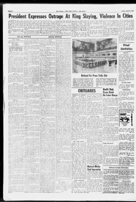
The act is not expected to sub- are Refused For Peace Talks Site This is the Council Chamber of the Palais des Nations at Geneva, Switzerland, which has reportedly been refused by Hanoi to be the scene of Vietnam peace talks. It was here that negotiations took place ending the war against the French in Indo-China, OBITUARIES FREDERICK E. WERNER GENOA Frederick E. Werner, 87, 1107 West Genoa, died at 11 p.m. Wednesday at Veterans' Administration Hospital, Cleveland, where he had been for treatment for five weeks.
Death was unexpected. He was a retired U.S. Immigration Inspector and served at the border at Detroit, starting in 1942. Mr. Werner was born in Genoa Nov.
16, 1880, son of Frederick and Bertha Sheirle Werner. He married the former Nettie H. Bophy in Detroit in 1939 and she died in April of 1964. A brother, John Werner of Genoa, is the only immediate survivor. A Spanish-American war veteran, Mr.
Werner a member of St. John's United Church of Christ; Genoa Masonic Lodge, 433; Oak Harbor Chapter RAM 162; Toledo Council; Toledo Knights Templar, Number Seven; Scottish Rite, Valley of Toledo, and Zenobia Shrine, Toledo. Friends may call at Robinson Funeral Home, Genoa, after 7 p.m. today. Services will be at 2 p.m.
Saturday from the funeral home, The Rev. T. J. Klaudt officiating. Burial will be in Clay cemetery where Masonic graveside services will be conducted.
MRS. JOHN KEKELIC Funeral services will be held Monday for Mrs. Gertrude F. Kekelik, 59, wife of John Kekelik, who died unexpectedly Thursday at her home, 114 Clemons Drive, Marblehead. Rites will be conducted at the Gerner and Wolf funeral home at 11 a.m.
Monday by the Reverend Father Charles Blank of St. Joseph's Catholic church in Marblehead. Burial will be made in St. Joseph's cemetery. Calling hours at the funeral home will start at 7 Saturday.
Mrs. Kekelik is survived by her husband John, whom she wed in 1952; three daughters, Mrs. Donald Elder and Mrs. Donna Mae Vargosick of Sandusky and Mrs. Kenneth Olson of Wilmington, four sisters, Mrs.
Richard Ogden of Vickery, Mrs. Harold Knecht of Lakewood, Mrs. William Kekic of Cleveland, and Miss Florence Williams of Cleveland; one brother Charles Williams of Bay Village and two grandchildren. She was born in Cleveland Nov. 12, 1908, daughter of Fred and Elizabeth Potts Williams.
AUGUST KNIERIEM ELMORE August Knieriem, 86, 303 Augusta Elmore, died Thursday evening in St. Charles Hospital where he was admitted earlier in the day after suffering a stroke in his home. Born in Elmore, April 23, 1881, he was the son of Adam and Minnie Hasselkus Knier- stantially break up large urban Negro slums immediately but should benefit middle-class Negroes who can afford to buy or rent better homes but who have been excluded on racial grounds. Pollak said some large housing developers have refused to sell or rent to Negroes on grounds that white residents would move or refuse to buy. Pollak said the new law leaves the developers no such reason to discriminate.
which resulted in the partitioning of North and South Vietnam and the creation of Laos and Cambodia. The United States and North Vietnam disagree on a site for possible peace talks, the U.S. wanting neutral territory. Health Dept. Eases Stand On Labor Camps The Ottawa County Health Department will ask operators of migrant labor camps to fulfill five requirements this year, a softening of an earlier stand that more stringent state regulations would have to be this year.
The five requirements, to be included in a form letter to be mailed soon, are: safe drinking water at the camp site, sanitary toilet facilities, water-tight garbage disposal facilities, a slop drain for liquid wastes and adequate heating facilities. Fulfillment of these requirements will mean granting of permits to operate migrant camps, according to the health department. In a related move, the health department has decided to drop fees for camp permits. According to Dr. H.
C. Sparks, camp operators may be granted permits before fulfilling sanitation requirements providing they have agreements with the department to have changes made by a specific future date. The health department revised its stand following a meeting at which several camp op'erators said they would not have time to meet the requirements. Only Bruised Ninety three feet of guard rail and six posts were taken out in a one-car accident at 2:55 a.m. Friday on county road 263, two miles west of Port Clinton.
driver of the car which hit the guard rail was Ronald Fleming, 19, of 5406 West Harbor Road. He sustained a bruised forearm but declined treatment. His 1957 car was towed in with extensive damages. Sheriff's department said Fleming was westbound when the car went out of control and off the left side the road. The bill provides for conciliation through the Department of Housing and Urban Development on questions of housing discrimination.
If conciliation fails to solve the issue HUD may file court suits or individuals may file their own suits in federal court. The new law requires individuals to work first through the framework of state or local open-housing laws when these laws are substantially equivalent to the federal law. This is the case in 11 of the 23 states with such laws. LEGAL LEGAL NOTICE The Board of Commissioners of Ottawa County, Ohio, met in Regular session with the following members present: COVER MR. JOHNSON MR.
FOREMAN Mr. Johnson moved the adoption are following resolution: A Resolution declaring the necessity of constructing certain water mains together with all necessary appurtenances, in Sewer District No. 7. WHEREAS, the Board of Commissioners of Ottawa County, Ohio, by resolution duly adopted on December 4, 1967, established Sewer District No. 7: and WHEREAS, on instructions of this Board, Finkbeiner, Pettis Strout, Consulting Engineers to this County, have heretofore prepared an amended general plan of water and water works for said District and detailed plans for water mains, together with all necessary appurtenances, in said Sewer District as it is now necessary to construct, said improvements to consist of water mains together with gate valve, fire hydrants, 6-inch hydrant water services and all other necessary appurtenances to be constructed in the al following locations and being hereinafter referred as Sewer District No.
7, Water ate Improvement Ww No. 2: SECTION A In the right-of-way of North Shore Boulevard, a public street consisting of approximately 7,156 feet of 12-inch water main beginning at the westerly terminus of original Sewer District No. 7 and extending westerly and southwesterly to a. terminus at the intersection of North Shore Boulevard and State Route No. 163.
SECTION In the right-of-way of State Route No. 163, a public street, consisting of approximately 1,591 feet of 12-inch, 5,840 feet of 10- inch and 1,008 feet of 8-inch water main, beginning at tersection of North Shore Boulevard and State Route 163 (southerly terminus of Section A) and extending northwesterly and westerly a distance feet to a terminus at the intersection of State Route No. 163 and Church Road (previously PicViolet Road), and also extending southeasterly and easterly from the intersection of North Shore Boulevard and State Route No. 163 a distance of 1,008 feet to the point of termination. SECTION (a) In a recorded roadway within Holiday Cove Allotment, approximately 747 feet of 6-inch water main, beginning at North Shore Boulevard and extending northerly to the point of termination.
(b) In Hidden Beach Road, a recorded roadway, approximately 1,561 feet 6-inch water main, beginning at North Shore Boulevard and extending northerly 799 feet to the point of termination and also extending southerly 762 feet to the point of termination. (c) In a recorded roadway within Shroek's Subdivision, approximately 787 feet of 6-inch water main, beginning at North Shore Boulevard and extending northerly and easterly to a terminus at Hidden Beach Road. (d) In a private lane within mately 184 feet of 2-inch water Schrock's Subdivision, a approximain, beginning at Hidden Beach Road and extending westerly to the point of termination. (e) In a recorded roadway within Berwyn Project Allotment, approximately 628 feet of 6-inch water main, beginning at North Shore Boulevard and extending southerly to the point of termination. (f) In a recorded roadway within Miley's Allotment, approximately 583 feet of 6-inch water main, beginning at North Shore Boulevard and extending northerly to the point of termination.
(g) In a recorded roadway within the Lake Harbor Villa Subdivision, approximately 754 feet of 6-inch in water main, beginning at North Shore Boulevard and extending northerly to the point of termination. (h) In. Perry View Road, a recorded roadway, approximately 1,659 feet of 6-inch water main, beginning at North Shore Boulevard and extending northerly 707 feet to Park Drive and also extending southerly 952 feet to the point of termination. (1) In a recorded roadway, bounded on the south by lots and 15 in Lake Vue Allotment, approximately 199 feet of 2-inch water main, beginning at Perry View Road and extending easterly to the point of termination. (j) In a recorded roadway, bounded on the south by lots 7, 8, and 9 in Lake Vue Allotment, approximately 199 feet of 2-inch water main, beginning at Perry View Road and extending easterly to the point of termination.
(k) In a recorded roadway, bounded on the south by lots 1, 2, and 3 in Lae Vue Allotment, approximately 199 feet of 2-inch water main, beginning at Perry View Road and extending eastto the point of termination. erly, In Meadow Brook Road, a recorded roadway, approximately 873 feet of 6-inch water main, beginning at North Shore Boulevard and extending northerly to Park Drive. (m) Willow Dale Road, a recorded roadway, approximately 932 feet 6-inch water main, beginning at North Shore Boulevard and extending northerly to Park Drive. (n) In a recorded Alley, in Ott's Subdivision, Block 1, approximately 168 feet of 6-inch water main, beginning at Willow Dale Road and extending westerly to a terminus at Gravel Bar Road. (0) In Park Drive, a recorded roadway, approximately 509 feet of 6-inch water main, beginning at Willow Dale Road and extending northeasterly and easterly to a terminus at Perry View Road.
(p) In Gravel Bar Road, a recorded roadway, approximately 1,238 feet of 8-inch end 3,554 feet of 6-inch water main, beginning at North Shore Boulevard and extending northerly a and westerly to a terminus at the westerly boundary of Gravel Bar Subdivision A. and extending northerly' to a terminus at Short Street. (t) In Park View Lane, a recorded roadway, approximately 988 feet of 6-inch water main, beginning at State Route No. 163 and extending northerly, easterly and northerly to a point of termination. (u) In Short Street, a recorded roadway, approximately 172 feet of 6-inch water main, beginning at Plum Street and extending westerly to a terminus at Park View Lane.
(v) In Harbor Street, a recorded roadway, approximately 60 feet of 2-inch main, beginning at Park View Lane and extending easterly to a point of termination. (w) In Maple Drive, a recorded roadway, approximately 889 feet of 6-inch water main, beginning at State Route No. 163 and extending northerly to. a point of termination. (x) In Tonsing Road, a recorded roadway, approximately 804 feet of 6-inch water main, beginning at State Route No.
163 and extending northerly to a point of termination. (y) In Elizabeth Drive, a recorded roadway, approximately 789 feet of 6-inch water main, beginning at State Route No. 163 and extending northerly to a point of termination. (z) In a recorded roadway in Tibble's Allotment, approximately 775 feet of 6-inch water main, beginning at State Route No. 163 and extending northerly to a point of termination, (aa) In Kimmel Drive, a recorded roadway, approximately 524 feet of 6-inch water main, beginning at State Route No.
163 and extending northerly to a point of termination. (bb) In Bass Road, a recorded roadway, approximately 419 feet of 6-inch water main, beginning at State Route No. 163 and extending northerly to a point of termination, and WHEREAS, said plans, together with specifications, estimates of cost and tentative assessments for said Water Improvement No. 2 have been filed with these Commissioners and are hereby approved, ratified and confirmed and copies of said plans, specifications, estimates and tentative assessments are filed in the office of the Clerk of this Board and are available for examination NOW. BE IT RESOLVED by the Board of Commissioners of Ottawa County, Ohio: Section 1.
That it is necessary at this time for the purpose of preserving, protecting and promoting the public health and welfare and providing fire protection to construct the water mains, together with all necessary appurtenances described in said detailed plans and specifica.tions and hereinafter referred to as being Sewer District No. 7, Water Improvement No. 2. Section 2. That the character of the materials for such water mains shall be cast iron with copper water services all as provided in said plans and specificasaid plans ante specifications for and reference is made to further information concerning the materials included in said improvement.
Section 3. That the estimated cost of the maintenance of Sewer District No. 7, Water Improvement No. 2 for one year is the amount of $2,000. Section 4.
That the entire cost of said improvement shall be specially assessed as an assessment district assessment against the benefited preperty within Sewer District No. 7, which benefited property is bounded and described as follows: Commencing at the northwesterly corner of Mazurik's First Subdivision and northwesterly corner of the original Sewer District No. 7 as established on July 24, 1961, in part Lot 4, Section 1 in Danbury Township, Ottawa County, Ohio, which point also on the shores of Lake Erie and of Beginning; thence southerly along the westerly line of subdivision to a point in the centerline of North Shore Boulevard; thence continuing southerly along the westerly line of lands, formerly or now owned by George Mazurik to a point, which point is located at the intersection of the southerly line of a parcel' No. 12 extended easterly, which parcel is formerly or now owned by the Chemstone Corporation, to westerly line of lands owned by George Mazurik; thence westerly along the southerly line extended and southerly line of lands of a Parcel No. 12, to the southwesterly corner of said Parcel No.
12, which point is located in Great Lot 2 in Section thence southerly along the westerly line of said Parcel No. 12 extended, a distance of 27 feet to the northeasterly corner of lands formerly or now owned by Elizabeth Orner. Christena Smith and Mary Richter; thence westerly along the northerly line of the last described parcel and this line extended westerly to a point on the westerly line of Section and easterly line of Section 2, which extended line also passes through Parcel No. 14, formerly or now owned by the Chemstone Corporation; thence southerly along the easterly line of Section 2 to a. point, which point is the intersection the southerly line of a parcel of land in Great Lot 13, Section 2, formerly or now owned by the Sandusky Council of Campfire Girls, tended easterly to the easterly line of Section 2: thence westerly along the" southerly line extended and southerly line of the Sandusky Council of Campfire Girls parcel to a point on the boundary of Schrock's Subdivision thence southerly along the easterly line of Schrock's Subdivision No.
4 to the southeasterly corner of Lot 118 in said subdivision: thence westerly along the southerly line of Lot -118-of said subdivision to the centerline of Hidden Beach Road; thence continuing westerly along the southerly line of Lot 224 in Schrock's Subdivision No. 5 to the southwesterly corner of said lot; thence southerly along the westerly boundary of Schroek's Subdivision No. 5 and the easterly boundary of Berwyn Project Allotment No. 2 to the southeasterly corner Vital Statistics HOSPITAL Admitted Thursday: Clarence Snyder, 124 Walnut, medical; Fred Schrader, Monroe medical; Mrs. Conrad Ward, Tettau Road, surgical; Mrs.
John Hensley, 4663 West Oak Harbor Road Southeast, medical; Mrs. Paul Hepp, 2535 West Cleveland, medical; Mrs. Stella Walters, Toledo, medical; Jane Stull 5158 Water, Catawba, medical; Edwin Bergman, East Port Clinton Road, medical; Harmon Deitzel, a Riverview Home, medical; William Ruper, Nugents, Canal, medical. Discharges: Stella Dunham, Donald Davis, Mrs. Fortino Guerra, John Genzman, Edward Roman, Mrs.
John Nissen, Tony Lochotzki, Mrs. Jerry Harper and daughter, Mrs Nellie Wellcome. Marriage Licenses Richard L. Jones, 30, Oregon, teacher, and Rosemary Feyes, 26, Lakeside, teacher; Father Paschal to officiate. EMERGENCIES iem.
His wife, the former Eleanore Mylander, died Sept. 13, 1958. Mr. Knieriem was a motorman for 30 years for the former Ohio Public Service electric line. Survivors include a brother, Jacob Knieriem, Elmore; sister, Mrs.
Harry (Lola) Huston, Columbus, and three nephews. Funeral services will be at 1:30 p.m. Monday in the R. F. Myers Funeral Home, Elmore where calling hours begin after 7 p.m.
Saturday. The Rev. Luther Redmon will conduct funeral services. Burial will be in Elmore Union Cemetery. ALBERT H.
GUMP Albert H. (Andy) Gump, 57, widely known Put-In-Bay resident, died suddenly at his home early this morning, victim of a heart attack. He had been in ailing health since 1963, and was retired as vice-president of the Hammer-Gump Company of Miller City, which manufactured dual wheels for tractors. Mr. Gump's body was brought to the Neidecker-LeVeck mortuary here, and is being returned to Put-In-Bay where it will be at the Gump residence.
Calling hours will start at 7 Saturday. Funeral services will be held Monday at 10 from Mother of Sorrows church, with the Reveredn James Risacher officiating. Burial will be made in Maple Leaf cemetery. Mr. Gump is survived by his wife, the former Marian Dodge; three sons James, Richard and Donald Gump of Put-In-Bay; and his stepfather, Ervin Hammer of Miller City, O.
He was born in Miller City April 16, 1910, and will be buried one day befor his 58th birthday. He was a World War II veteran, serving with the Coast Guard and saw service in the Pacific and Alaska as well as being stationed in Michigan. He was active in Schaible-Downing Post 542, American Legion, the Chamber of Commerce and belonged to Mother of Sorrows church. Richard Maloy Said Improving Police Chief Henry Jacoby said Patrolman Richard Malloy, injured Sunday evening in an accident while chasing a speeder, is still in an 1 intensive care unit in Mercy Hospital in Toledo. Jacoby said, "His condition is much improved and his outlook is excellent because he wants to come back to work." Personnel in intensive care at Mercy Hospital report Malloy "doing fairly well and They report only his family may visit, and there are no plans at this time for moving him out of intensive care.
7 Susan Smith 10, daughter of Mr. and Mrs. Tom Smith of Erie Industrial Park, dog bite of lower right Tim Glovinsky, son of Mr. and Mrs. William Glovinsky of 324 Laurel; hit on head by swing.
Mrs. William Blumensaadt, 127 Lenden, sprain of right ankle in fall from couch. Mrs. Michael Roby, Erie Industrial Park, contusions of shoulder and hip, auto accident. Stay In The "Know" With VFW Auxiliary 2480 Easter Egg Sale, 65 cents a dozen.
Post Home April 12 and 13. Adv. 4-12 Bake Sale April 12, 10 to 12 noon and 3-6 p.m. at Oak Harbor Hardware. Sponsored by Oak Harbor Conservation Club Women's Auxiliary.
Adv. 4-11 Annual Catawba Island Volunteer Firemen's Pig Hocks and Sauerkraut Feed, April 17, serving 5:30 to 8 p.m. at the Catawba Island Community Hall. Donations $1.75 per person. Home cooked by the fireman.
Adv 4-17 Sunset Nite Club, live entertainment Fri. and Sat. Adv. (M-F-ff) Best selecton of Easter flowers now at Woner's Greenhouse, 118 W. 6th phone 734-1721.
Order now. Corsages, potted plants, bouquets, cut flowers arrangements. Out-of-town orders given prompt Ottawa County Directory Ottawa County Ottawa county Court House, Port Clinton: 8:30 a.m. to 4:30 p.m., Monday through 8:30 a.m. to 6 p.m.
Closed Saturday. Port Clinton Publle Library, Second and Adams: 12:30 to 8:30 p.m., Monday through Thursday. 12:30 10 6:30 p.m. Friday. 9:30 a.m.
to 5:30 p.m. Saturday, Ottawa County Selective ServIce, 107 East Second 8:00 8.11 Ottawa County Historical Mu. p.m. Monday through Friday. Closed Saturday, senm, city hall: 6:30 p.m.
to 8:30 p.m. Wednesday and Saturday. 3:00 p.m. to 5:00 p.m. Thurday and Saturday.
Ottawa County Red Cross, 232 East Second Port Clinton: 8:30 a.m. to 4:30 p.m.. Monday through Friday Port Clinton City Hall: Pollee department open 24 hours days.a week. Tax commissioner and safety service director office. 9:00 a.m.
to 4:30 p.m. Monday through Friday. 9:00 a.m. to noon Saturday, Closed noon 1:00 p.m. City auditor: 9:00 a.m.
to 4:30 p.m. Monday through Friday, Port Clinton Municipal Court, City Hall: 8:30 a.m. to 4:30 p.m. Monday through Thursday, 8:30 a.m. to 6:00 p.m.
Friday THE DAILY NEWS Phone 734-3141 Publication Office, 114 E. Fifth Port Clinton, Ohio 43452. Published Monday through Friday except holidays by R. George Kuser, Inc. Entered as second class matter at Port Clinton post office.
Act of 1879. Subscription rates, per copy. If your newspaper is not delivered by 5 p.m., or if there is any other irregularity in delivery, the circulation manager would appreciate it if you would call The Daily News..
Get access to Newspapers.com
- The largest online newspaper archive
- 300+ newspapers from the 1700's - 2000's
- Millions of additional pages added every month
Publisher Extra® Newspapers
- Exclusive licensed content from premium publishers like the News Herald
- Archives through last month
- Continually updated
About News Herald Archive
- Pages Available:
- 299,058
- Years Available:
- 1857-2024